
The Madison River: 50 Miles from Quake Lake to Ennis
By Bobby Harris — Navy FMF Corpsman (2002–2010), founder of First Rise Outfitters
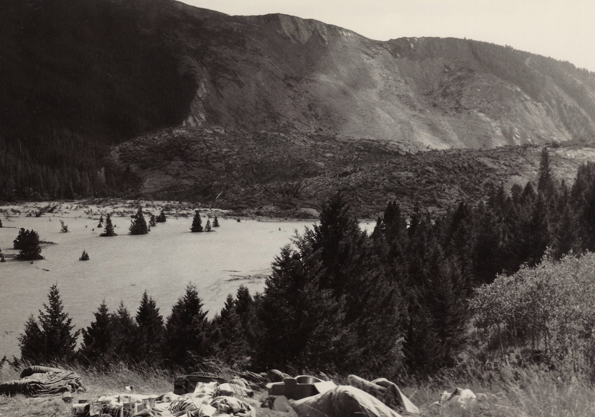
The upper Madison River is known to anglers as the fifty-mile riffle: a steady, walking-pace run of cobble and broken current between Earthquake Lake and Ennis Lake. Montana Fish, Wildlife and Parks calls it a top destination for anglers worldwide, and also one of the state's most heavily used river fisheries. What most people standing in it do not know is that the lake at the top of that run did not exist before 11:37 p.m. on August 17, 1959, when a mountain came down and dammed the river in under a minute.
Key takeaways
- Earthquake Lake was created in 1959 when a magnitude 7.3 earthquake collapsed a canyon wall into the Madison River.
- The slide was the largest seismically triggered landslide in recorded North American history.
- Twenty-six people died at the Rock Creek campground, and 19 of them were never recovered.
- The upper Madison below the slide runs about 50 miles to Ennis Lake and is known as the fifty-mile riffle.
- The Madison carries section-specific regulations that differ from general Montana rules, so check current FWP regulations before you fish.
In this article
- Where does the Madison River start and end?
- What created Quake Lake?
- What happened that night at Rock Creek
- Why is it called the fifty-mile riffle?
- The river at a glance
- What to check before you fish it
- FAQ
Where does the Madison River start and end?
The Madison River begins inside Yellowstone National Park, at the confluence of the Firehole and Gibbon rivers near the park's West Gate. Montana FWP traces the rest of the course: shortly after leaving the park the river is impounded by Hebgen Dam, creating the 12,000-acre Hebgen Reservoir. Eight miles downstream it is stopped again, this time by what FWP describes as "a natural, earthen dam that resulted from a landslide triggered by a magnitude-7.3 earthquake in 1959."
Below that natural dam, 90 miles of river run to the Missouri. Ennis Lake splits it into two very different halves. The upper Madison above Ennis Lake is the trout water this article is about. Below Ennis Lake the river drops 8 miles through Beartrap Canyon, a designated wilderness with Class III to V rapids, then runs a final 40 miles to join the Jefferson and Gallatin and form the Missouri River at Missouri Headwaters State Park outside Three Forks.
One river, three impoundments, and two completely different characters on either side of the middle one.
What created Quake Lake?
Earthquake Lake was created by a landslide, not by a dam anyone built. At 11:37 p.m. local time on Monday, August 17, 1959, the magnitude 7.3 Hebgen Lake earthquake struck near the mouth of Madison Canyon, west of Hebgen Lake. According to the U.S. Geological Survey, it "unleashed the largest seismically triggered landslide in North America in recorded history."
The numbers are hard to hold in your head. A section of the south canyon wall 1,300 feet high collapsed northward into the canyon. The mass swept 430 feet up the opposite wall in places. It came to rest as a dam 220 feet high across the Madison River, and the lake behind it began filling immediately. USGS puts the volume of the slide at 37 to 43 million cubic yards, covering 130 acres, extending a mile from head scarp to toe and three quarters of a mile wide.
The geology explains why it let go all at once. A thick layer of Precambrian dolomite dips steeply along the base of the south canyon wall, and that hard layer had been acting as a buttress holding up deeply weathered schist and gneiss above it. The shaking broke the buttress, and the whole wall went. The slide kept its layers in order as it moved, which is why the dolomite still forms a tan band along the leading edge with the dark schist and gneiss behind it.

What happened that night at Rock Creek
The slide reached the canyon floor within seconds of the shaking, and the campground below took the worst of it. Eyewitnesses told USGS the Madison Slide came down anywhere from a few seconds to perhaps half a minute after the strongest shaking had subsided. Its upstream edge buried the overflow camping area just below the Forest Service's Rock Creek Campground.
Twenty-six people died there. Nineteen of them were never recovered and are presumed entombed in the slide mass.
The slide did not only bury. A wave of muddy water ran along its upstream edge carrying trees, driftwood, and rock up to 100 feet above the river on the north canyon wall, and the mass displaced a hurricane-force air blast ahead of it. USGS attributes many of the casualties, and the destruction of vehicles and trailers in the campground, to the wave and the blast rather than the debris itself.
By 6:30 the next morning the new lake had covered every car and trailer in Rock Creek Campground and was at least 20 feet deep. About 250 survivors gathered on Refuge Point, the highest ground between the slide and Hebgen Dam. They were trapped: the earthquake had also damaged the road upstream, so there was no way out of the canyon in either direction. Air Force helicopters lifted out the most seriously injured around midday.
Why is it called the fifty-mile riffle?
The name describes what the river does for the whole run below the slide. Montana FWP records the nickname directly: "The upper Madison River above Ennis Lake, affectionately known by trout anglers as the 50-mile riffle, is a top destination for anglers worldwide."
A riffle is normally a feature you fish through and then leave. On the upper Madison it is the entire character of the river for roughly fifty miles. The gradient stays steady, the bottom stays cobble, and the current keeps moving at something close to a walking pace without collecting into the long deep pools that structure most trout rivers. There is no obvious lie to work toward, because the whole run reads as holding water.
That character is a direct consequence of the geology above it. The 1959 slide set the elevation at the top of the run, and the valley below carries a consistent grade down to Ennis Lake.
It comes with a cost. FWP notes in the same breath that the upper Madison is "one of Montana's most heavily used river fisheries." Solitude is not what this stretch offers.

The fifty-mile riffle, drawn as a mileage marker for the river you keep going back to.
The river at a glance
| Feature | Detail |
|---|---|
| Source | Confluence of the Firehole and Gibbon rivers, Yellowstone National Park |
| First impoundment | Hebgen Dam, forming a reservoir of over 12,000 acres |
| Second impoundment | Earthquake Lake, a natural earthen dam from the 1959 slide, 8 miles below Hebgen |
| River below Earthquake Lake | 90 miles to the Missouri, split by Ennis Lake |
| Upper Madison | The fifty-mile riffle, Earthquake Lake down to Ennis Lake |
| Below Ennis Lake | 8 miles of Class III to V water through Beartrap Canyon wilderness |
| Confluence | Joins the Jefferson and Gallatin at Missouri Headwaters State Park, Three Forks |
| 1959 slide volume | 37 to 43 million cubic yards, covering 130 acres |
| Natural dam height | 220 feet across the Madison River |
River course and impoundments per Montana Fish, Wildlife and Parks. Slide measurements per the U.S. Geological Survey.
What to check before you fish it
The upper Madison carries section-specific regulations that do not match Montana's general river rules, and they are the kind that change. Restrictions on fishing from a boat apply on parts of this stretch, some sections run under different terminal tackle and release rules than others, and the boundaries between those sections are drawn at specific bridges and access sites rather than at obvious landmarks.
Because those rules are revised and because getting one wrong is a citation rather than a debate, this article does not list them. Read the current Montana FWP fishing regulations for the Madison before your trip, and confirm which section you are standing in.
One requirement is worth knowing in advance regardless. FWP requires a Special Recreation Permit for all commercial use, competitive events, and organized group activities on the Madison and at all Madison River FWP and BLM access sites, from the outlet of Earthquake Lake to the confluence with the Jefferson. If you are organizing anything beyond a private trip with friends, that applies to you.
Our catch and release guide covers handling once you are on the water.
Frequently asked questions
What created Quake Lake in Montana?
A landslide did. On August 17, 1959, a magnitude 7.3 earthquake near Madison Canyon collapsed a 1,300-foot section of the south canyon wall into the Madison River. The debris formed a natural dam 220 feet high, and the lake behind it began filling immediately. The U.S. Geological Survey describes it as the largest seismically triggered landslide in recorded North American history.
How many people died in the 1959 Madison Canyon slide?
Twenty-six people died at the overflow camping area below Rock Creek Campground, and 19 of them were never recovered and are presumed entombed in the slide mass. Many casualties were caused not by debris but by a wave of muddy water and a hurricane-force air blast the slide pushed ahead of itself as it fell.
Why is the upper Madison called the fifty-mile riffle?
Because the river holds riffle character for roughly fifty miles rather than a short stretch. Montana FWP records the nickname for the upper Madison above Ennis Lake. The gradient stays steady and the bottom stays cobble, so the current keeps a walking pace without forming the long deep pools that structure most trout rivers.
How long is the Madison River below Earthquake Lake?
Montana FWP puts it at 90 miles from the outlet of Earthquake Lake to the Missouri. Ennis Lake divides that into the upper Madison, the fifty-mile riffle, and the lower Madison, which runs 8 miles through Beartrap Canyon and then a final 40 miles to Missouri Headwaters State Park at Three Forks.
Do you need a special permit to fish the Madison River?
For a private trip you need a Montana fishing license and must follow the section-specific regulations, which differ along this river and change over time. Check the current FWP regulations before you go. A Special Recreation Permit is separately required for all commercial use, competitive events, and organized group activities from the outlet of Earthquake Lake to the Jefferson confluence.
Sources
- The 1959 Madison Slide, Part 1: A deadly consequence of the Hebgen Lake Earthquake, Yellowstone Volcano Observatory, U.S. Geological Survey, 2024
- Madison River Recreation, Montana Fish, Wildlife and Parks
- Historical photography: J. R. Stacy / USGS and William B. Hall, Montana School of Mines, public domain
The Rivers You Fish. The Species You Chase.
Field-guide inspired apparel celebrating native trout, wild rivers, and the places worth getting up before daylight for.
Shop the Collection →Free shipping on orders over $75.